
The southwest monsoon, or habagat, will continue to bring rains to parts of Luzon, while generally fair weather is expected across most of the country on Friday, August 21, the Philippine Atmospheric, Geophysical and Astronomical Services Administration (PAGASA) said.
In its 5 a.m. weather forecast, PAGASA said the habagat is currently affecting parts of Ilocos Norte, Ilocos Sur, Abra, Apayao, Cagayan, and Batanes, where partly cloudy to cloudy skies and scattered rains may be experienced.
Generally fair weather is expected over most parts of the country on Friday, with localized rain showers and thunderstorms possible in other areas, particularly in the afternoon and evening.
"Ngayong araw, inaasahan natin mapapansin niyo, halos walang masyadong kaulapan dito sa ating bansa. Kaya po, generally, fair weather sa malaking bahagi ng ating kapuluan," weather specialist, Obet Badrina said.
PAGASA said the weak habagat is expected to persist through Saturday, August 22.
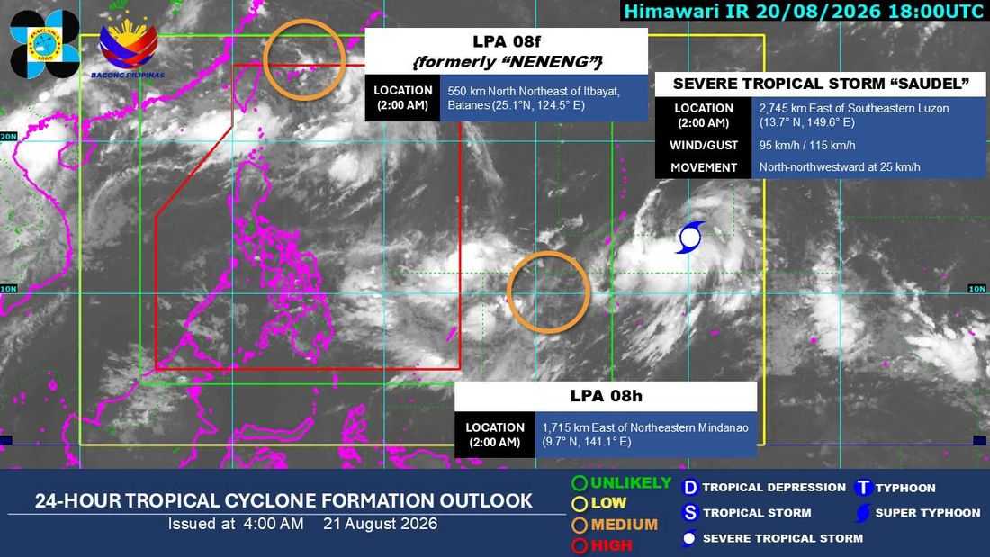
As of 3 a.m. Friday, LPA 08F, formerly monitored as “Neneng,” was located outside the PAR near Taiwan after weakening from a tropical cyclone. PAGASA said it is no longer affecting the country.
LPA 08H, was also being monitored outside the PAR. It has a medium chance of developing into a tropical depression within the next 24 hours and was located around 1,700 kilometers east of Mindanao. PAGASA said the weather disturbance is unlikely to enter the PAR and is not expected to significantly affect the country.
Meanwhile, Severe Tropical Storm Saudel was also being monitored outside the PAR, 2,735 kilometers east of southeastern Luzon with maximum sustained winds of 95 kilometers per hour near the center and gustiness of up to 115 kph. It was moving north-northwestward at 25 kph. PAGASA said Saudel could enter the PAR between Sunday and Monday.
The agency said Saudel may cause the habagat to strengthen again from Sunday through Tuesday. Once it enters the PAR, it will be given the local name Obet.
Should this happen, cloudy skies with scattered rains and thunderstorms may return to parts of Ilocos Norte, Ilocos Sur, Abra, Apayao, Cagayan, and Batanes.
The rest of Luzon may experience generally fair weather with localized thunderstorms. Similar conditions are expected in Palawan, the Visayas, and Mindanao, with rain showers and thunderstorms likely mainly in the afternoon and evening.
PAGASA also said there is currently no gale warning over any part of the country, indicating that sea conditions remain generally favorable for marine travel.
The agency, however, advised the public and mariners to continue monitoring its latest weather updates, particularly as Saudel moves closer to the PAR.
