
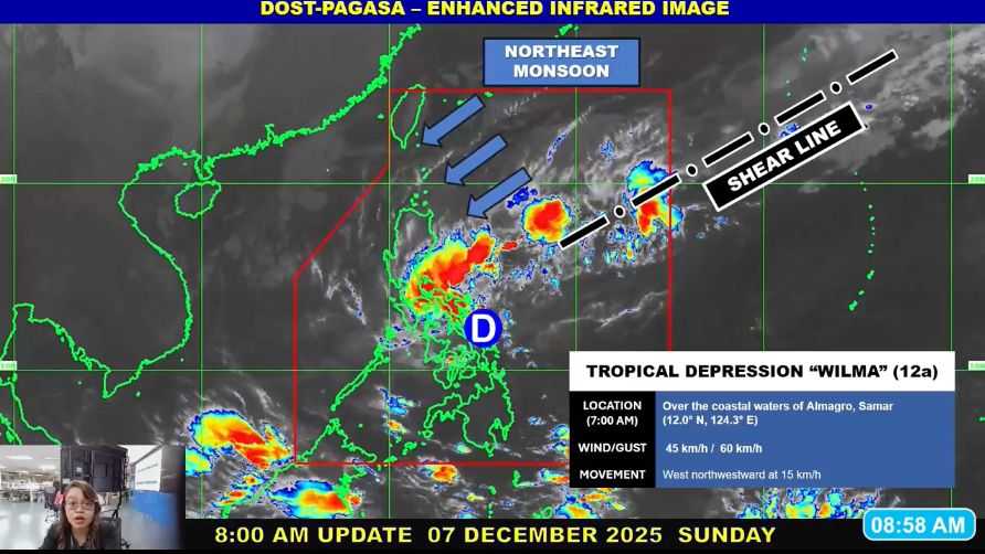
Tropical Depression Wilma has begun moving west to west-southwest while over the coastal waters of Almagro, Samar, bringing heavy rain, strong winds, and hazardous sea conditions across parts of Luzon, Visayas, and Mindanao.
As of 8:00 a.m., Wilma was located over the coastal waters of Almagro, Samar. It was moving west-northwest at 15 kilometers per hour, carrying maximum sustained winds of 45 km/h near the center and gusts of up to 60 km/h.
State weather forecasters said Wilma is expected to continue tracking generally west-southwest, crossing Southern Luzon and the Visayas today before emerging over the Sulu Sea.
The system is forecast to remain a tropical depression as it passes through land areas but may weaken earlier into a low-pressure area due to the surge of the Northeast Monsoon.
Heavy Rain and Strong Winds
The public was advised to refer to Weather Advisory No. 15 for the expected heavy rainfall due to Wilma and the ongoing shear line. Officials warned that heavy rain and strong winds may still be experienced outside the projected landfall point and forecast path.
Wind Signal No. 1 remains hoisted in several areas, where minimal to minor impacts from strong winds are possible. Local winds may intensify along coastal and upland or mountainous areas.
Areas under Tropical Cyclone Wind Signal No. 1
Luzon:
-
Sorsogon
-
Masbate, including Ticao and Burias Islands
-
Romblon
-
Southern Oriental Mindoro (Bulalacao, Mansalay, Roxas, Bongabong, Bansud)
-
Southern Occidental Mindoro (Magsaysay, San Jose, Rizal, Calintaan, Sablayan)
Visayas:
-
Northern Samar
-
Eastern Samar (north and central portions):
-
Can-Avid
-
Maslog
-
Borongan City
-
San Policarpo
-
Taft
-
Maydolong
-
Dolores
-
Jipapad
-
Oras
-
Arteche
-
Balangkayan
-
Sulat
-
San Julian
-
-
Samar (north and central portions):
-
San Jorge
-
San Sebastian
-
Santa Rita
-
Villareal
-
Zumarraga
-
Matuguinao
-
Pinabacdao
-
Almagro
-
Calbayog City
-
Talalora
-
Jiabong
-
Pagsanghan
-
Catbalogan City
-
Gandara
-
Motiong
-
Santo Niño
-
Tagapul-an
-
San Jose de Buan
-
Santa Margarita
-
Tarangnan
-
Calbiga
-
Daram
-
Paranas
-
Basey
-
Hinabangan
-
-
Biliran
-
Northern Leyte:
-
Tunga
-
San Miguel
-
Matag-ob
-
Calubian
-
Leyte
-
Carigara
-
Babatngon
-
Jaro
-
San Isidro
-
Santa Fe
-
Villaba
-
Capoocan
-
Alangalang
-
Tabango
-
Tacloban City
-
Kananga
-
Barugo
-
Palo
-
Pastrana
-
-
Northern Cebu, including Bantayan Islands:
-
Daanbantayan
-
Medellin
-
Bogo City
-
San Remigio
-
Tabogon
-
-
Northern Negros Occidental:
-
Sagay City
-
Escalante City
-
Enrique B. Magalona
-
Victorias City
-
Manapla
-
Cadiz City
-
-
Central and Eastern Iloilo:
-
San Dionisio
-
Estancia
-
Batad
-
Carles
-
Concepcion
-
Ajuy
-
Sara
-
Balasan
-
Lemery
-
Barotac Viejo
-
San Rafael
-
Passi City
-
San Enrique
-
Anilao
-
Banate
-
Dingle
-
Barotac Nuevo
-
Mina
-
Pototan
-
New Lucena
-
Santa Barbara
-
Leganes
-
Zarraga
-
Dumangas
-
Dueñas
-
Bingawan
-
Lambunao
-
Calinog
-
Janiuay
-
Badiangan
-
Cabatuan
-
Maasin
-
Alimodian
-
San Miguel
-
Leon
-
Tubungan
-
Igbaras
-
-
Capiz
-
Aklan
-
Antique (north and central), including Caluya Islands:
-
Patnongon
-
Sibalom
-
Barbaza
-
Valderrama
-
Pandan
-
San Jose
-
Bugasong
-
Culasi
-
Sebaste
-
Tibiao
-
San Remigio
-
Libertad
-
Belison
-
Laua-an
-
Hamtic
-
Residents in affected areas are advised to monitor official weather bulletins, prepare for possible flooding and wind damage, and avoid sea travel as conditions remain hazardous.