The Office of Civil Defense (OCD) on Friday warned that Typhoon Uwan — which could intensify into a super typhoon — may bring widespread impacts across much of the country, from Batanes to Bohol, over the weekend.
Assistant Secretary Rafael Alejandro IV of the OCD said preparations are underway across Northern Luzon and parts of the Visayas due to the storm’s massive size and expected strength.
“Ang areas of concern natin ay talagang to Northern Luzon, Regions I, CAR, 2, 3, CALABARZON, ang Region 5 kasi napakalaki ng bagyong ito. It might reach... puwedeng umabot sa Region 6, 7 and 8,” he said.
“We are preparing physically for the entire Northern Luzon Island and Visayas for the possible impact nitong Bagyong Uwan,” Alejandro said.
Alejandro warned the public to remain vigilant, stressing that the weather system’s impact could be widespread.
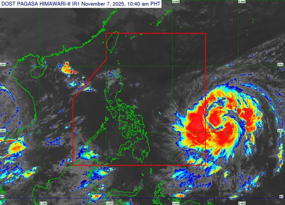
“Napakalaki nitong bagyo. Ang radius nito ay 700 kilometers from the center—times two, 1,400 kilometers in diameter. Batanes to Bohol ang maaaring maapektuhan,” he added.
“Ito po ay pinaghahandaan natin, napakalaki po nito,” he said.
According to the Department of Environment and Natural Resources’ Mines and Geosciences Bureau, 8,164 barangays may be affected by landslides and floods triggered by Uwan’s heavy rains.
OCD estimates show that around 5.7 million people could be affected or displaced once Uwan hits land.
Meanwhile, in the Philippine Atmospheric, Geophysical and Astronomical Services Administration's (PAGASA) press conference, Dr. Nathaniel Servando, administrator of the PAGASA, said Uwan’s track is similar to that of Super Typhoon Pepito, which struck around the same period last year.
“Mga nagdaang bagyo last year, bandang October–November, series of strong typhoons. Isa na ang Pepito kung titignan natin halos may similarity ang track. I think Super Typhoon din ’yun and almost the same areas,” Servando said.
In its 11:00 a.m. bulletin that the center of Severe Tropical Storm Fung-Wong (international name of Uwan) was estimated at 1,315 kilometers east of Eastern Visayas, outside the Philippine Area of Responsibility (PAR).
The bureau said that typhoon's maximum sustained winds of 100 km/h near the center, gustiness of up to 125 km/h and west-northwestward at 20 km/h.
PAGASA may raise Signal No. 5 — the highest wind warning — in Northern Luzon early next week as the region braces for life-threatening winds and severe weather.
"In terms of how strong the wind is maaring aabutin ito ng more than 185 kmh, isa lamang ito sa mga hazards na dala ng bagyong Uwan pag pumasok ng PAR,” said Servando.
Uwan is expected to enter the PAR on Friday evening or early Saturday morning, November 8.