- Catanduanes
- Albay
- Sorsogon
- Ticao Island
- Eastern portion of Camarines Sur, including: Siruma, Tinambac, Goa, Lagonoy, Buhi, Caramoan, Tigaon, Garchitorena, Calabanga, Sagñay, San Jose, Presentacion, Baao, Ocampo, Milaor, Nabua, Bato, Camaligan, Pili, Iriga City, Magarao, Minalabac, Balatan, Naga City, Bombon, Bula, and Canaman
Typhoon Uwan rapidly intensifies; Signal No. 2 raised in 8 areas
Nation
Typhoon Uwan rapidly intensifies; Signal No. 2 raised in 8 areas
by Luwela Amor08 November 2025
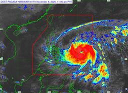
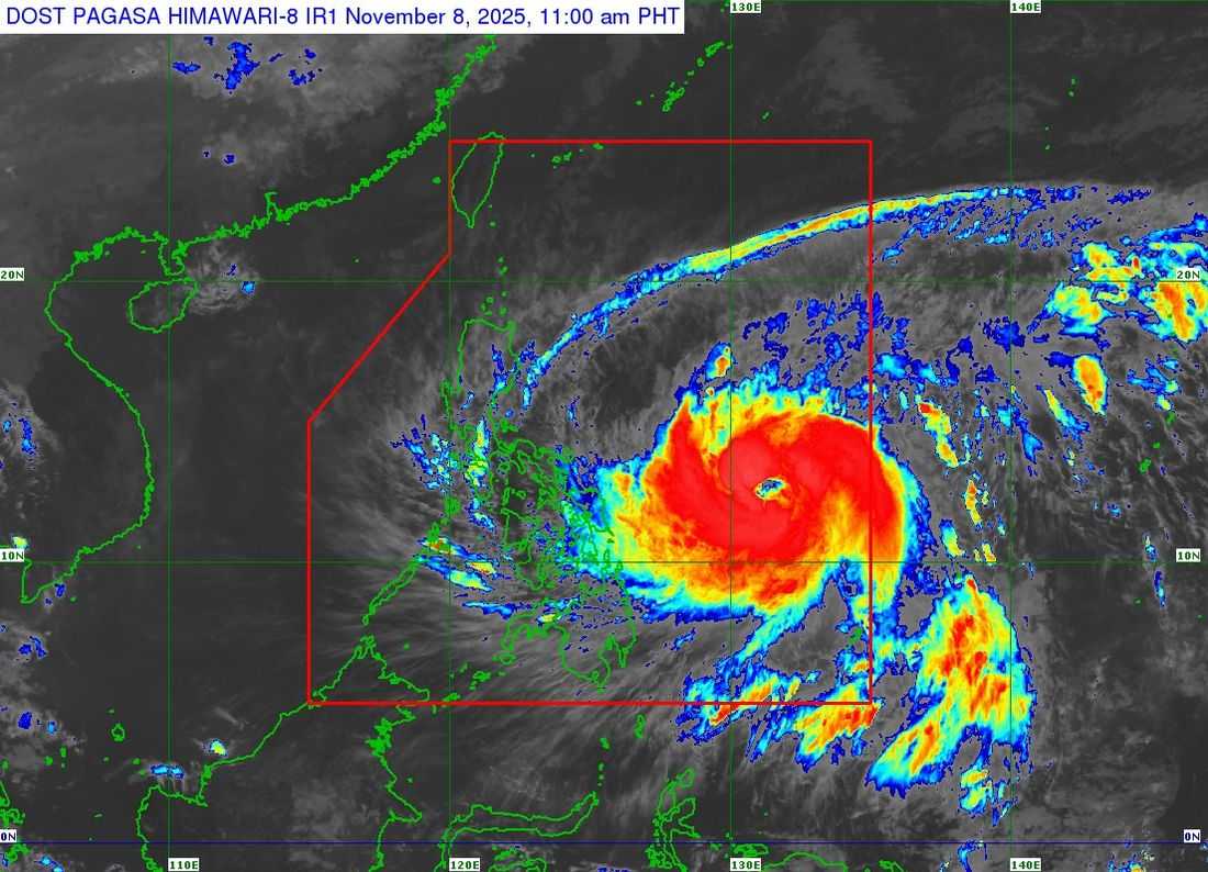
Photo courtesy: DOST-PAGASA
Typhoon Uwan continues to intensify as it moves westward toward the Eastern Visayas region, according to the Philippine Atmospheric, Geophysical and Astronomical Services Administration (PAGASA).
In the 11:00 a.m. bulletin, the center of Typhoon Uwan was estimated at 680 km east of Borongan City, Eastern Samar, or 760 km east of Catarman, Northern Samar.
The typhoon carries maximum sustained winds of 140 km/h near the center, gustiness of up to 170 km/h. It is moving at a speed of westward at 35 km/h.
Strong to typhoon-force winds extend outward up to 780 km from the center, bringing the threat of damaging winds and heavy rainfall to several provinces in the coming days.
TCWS 2
Luzon
Visayas
- Northern Samar
- Northern portion of Samar, including: (Matuguinao, San Jose de Buan, Calbayog City)
- Northern portion of Eastern Samar, including: (Maslog, San Policarpo, Dolores, Jipapad, Oras, Arteche)
TCWS 1
Luzon
- Batanes
- Cagayan
- Metro Manila
- Calamian Islands
- Northern and Central Luzon
- Calabarzon
- Mimaropa
- Bicol Region
Visayas
- The rest of Samar and Eastern Samar
- Biliran
- Leyte
- Southern Leyte
- Northeastern Bohol
- Northern and Central Cebu (including Bantayan and Camotes Islands)
- Northern Negros Occidental
- Northern and Central Iloilo
- Capiz
- Aklan
- Northern and Central Antique, including Caluya Islands
Mindanao
- Dinagat Islands
- Surigao del Norte
PAGASA warned that Typhoon Uwan continues to intensify and may reach the super typhoon category as it moves closer to Luzon, potentially bringing heavy rainfall, severe winds, and storm surges across wide areas even beyond its forecast track.
After landfall, Typhoon Uwan is forecast to cross the mountainous terrain of Northern Luzon, weakening slightly due to land interaction before re-emerging over the Lingayen Gulf or the coastal waters of Pangasinan or La Union by Monday morning or afternoon.
PAGASA warned the public that hazardous weather may affect areas far from the landfall point and even outside the forecast confidence cone, with flooding, landslides, and coastal inundation remaining possible in several regions.
Share
Related Topics