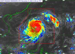
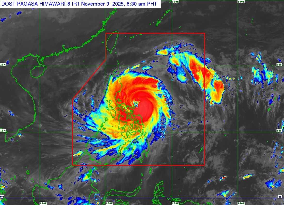
Super Typhoon UwanPH (Fung-Wong) has intensified into a super typhoon, bringing life-threatening conditions to Catanduanes and surrounding areas, the PAGASA reported Sunday morning.
As of 7:00 AM, the typhoon’s eye was located 125 km east-northeast of Virac, Catanduanes (14.0°N, 125.3°E), moving west-northwest at 25 km/h.
Uwan packs maximum sustained winds of 185 km/h, gusts up to 230 km/h, and a central pressure of 935 hPa. Its winds extend up to 800 km from the center, affecting a wide swath of Luzon, Visayas, and parts of Mindanao.
Tropical Cyclone Wind Signals (TCWS) in Effect:
TCWS No. 5
- Polillo Islands
- Northern Camarines Norte: Daet, Talisay, Paracale, Vinzons, Jose Panganiban, Mercedes, Basud
- Eastern Camarines Sur: Siruma, Caramoan, Garchitorena, Tinambac, Lagonoy
- Catanduanes
TCWS No. 4
- Eastern Quezon: Tagkawayan, Calauag, Guinayangan, Perez, Alabat, Quezon
- Rest of Camarines Norte and Camarines Sur
- Eastern Albay: Rapu-Rapu, Bacacay, City of Tabaco, Malilipot, Malinao, Tiwi, Polangui
TCWS No. 3
- Southern Cagayan: Tuao, Enrile, Solana, Tuguegarao City, Peñablanca, Iguig, Piat, Amulung
- Isabela, Quirino, Nueva Vizcaya, Southern Apayao (Conner), Kalinga, Abra, Mountain Province, Ifugao, Benguet, Ilocos Sur, La Union
- Pangasinan, Zambales, Bataan, Tarlac, Pampanga, Nueva Ecija, Bulacan, Aurora, Metro Manila, Cavite, Batangas, Laguna, rest of Quezon, Marinduque, rest of Albay, Sorsogon
-
Northern Samar, Northern Eastern Samar (Jipapad, Arteche, San Policarpo, Oras, Dolores, Maslog)
-
Northern Samar: Calbayog City, Matuguinao, Gandara, Santa Margarita, San Jose de Buan
-
TCWS No. 2 – Minor to moderate threat (Gale-force winds, 62–88 km/h)
-
Rest of Cagayan including Babuyan Islands
-
Rest of Apayao, Ilocos Norte, Occidental and Oriental Mindoro, Romblon, Rest of Masbate
-
Rest of Eastern Samar, Rest of Samar, Biliran, Northern and central Leyte
TCWS No. 1
-
Batanes, Calamian Islands, Cuyo Islands
-
Rest of Leyte, Southern Leyte, Bohol
-
Northern and central Cebu: Medellin, Daanbantayan, Bogo, Tabogon, San Remigio, Tabuelan, Borbon, Sogod, Tuburan, Catmon, Carmen, Danao City, Compostela, Liloan, Consolacion, Lapu-Lapu City, Mandaue City, Cordova, Asturias, Cebu City, Balamban, Talisay, Toledo, Minglanilla, Dumanjug, Argao, Sibonga, Barili, Ronda, Moalboal, Badian, Dalaguete, Alcantara, Carcar, City of Naga, San Fernando, Pinamungahan, Aloguinsan, Bantayan and Camotes Islands
-
Northern and central Negros Occidental: Escalante, Toboso, Sagay, Cadiz, Calatrava, Manapla, Victorias, Enrique B. Magalona, Silay, Talisay, San Carlos, Salvador Benedicto, Murcia, Bacolod, Hinigaran, Himamaylan, Binalbagan, Isabela, Moises Padilla, La Castellana, Pontevedra, San Enrique, La Carlota, Bago City, Pulupandan
-
Northern Negros Oriental: Canlaon, Jimalalud, La Libertad, Tayasan, Vallehermoso, Guihulngan
-
Guimaras, Iloilo, Capiz, Aklan, Antique
-
Mindanao: Dinagat Islands, Surigao del Norte, northern Agusan del Norte (Tubay, Santiago, Jabonga, Kitcharao), northern Surigao del Sur (Carrascal, Cantilan, Madrid, Carmen, Lanuza, Cortes)
Other Hazards:
-
Heavy rainfall may trigger flooding and landslides; check PAGASA Weather Advisory No. 9.
-
Coastal flooding with storm surges exceeding 3.0 m is possible in low-lying areas of Luzon, Visayas, and Mindanao.
-
Hazardous seas: Sea travel is risky for all types of vessels; mariners are advised to seek shelter immediately.
Authorities remind residents to take all necessary measures to protect life and property, especially in areas highly susceptible to strong winds, heavy rains, and storm surge.