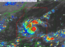
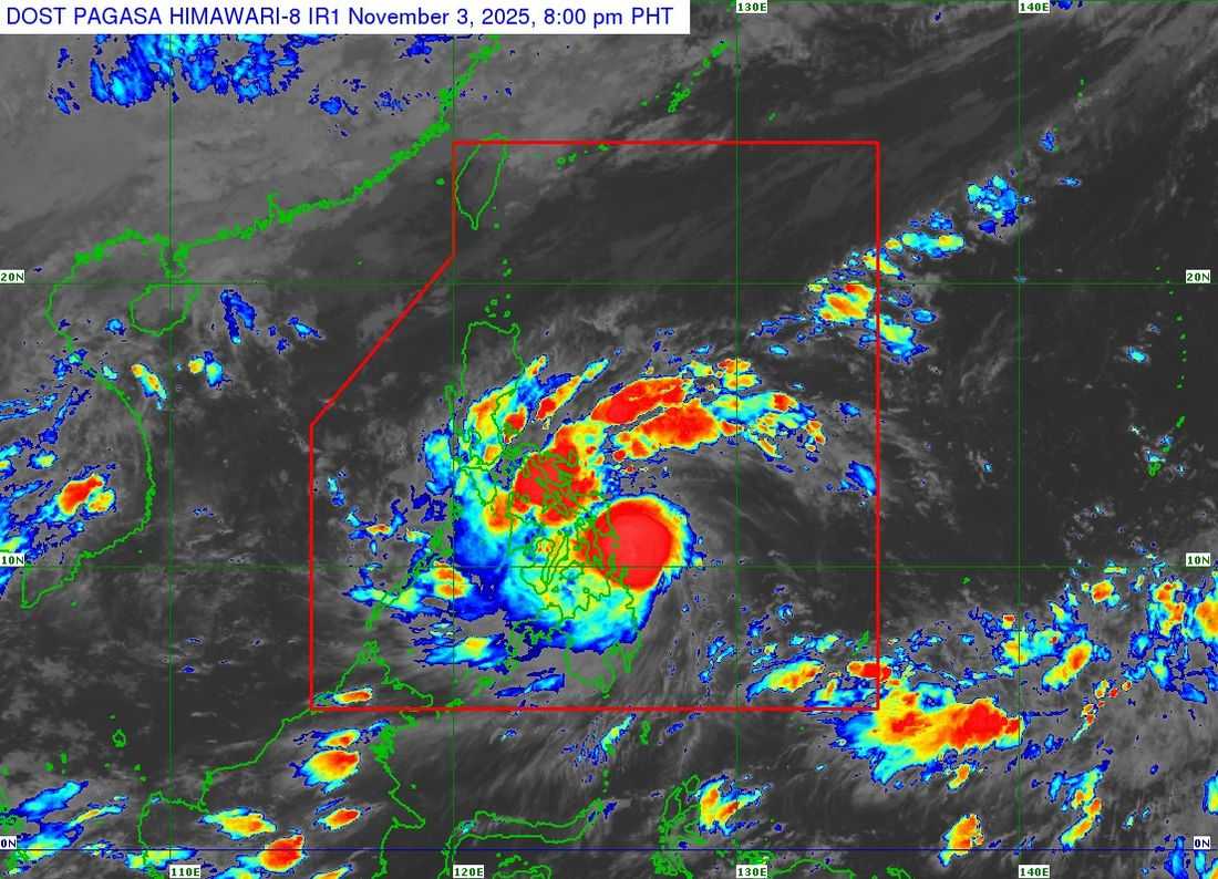
Typhoon Tino has further intensified while moving west northwestward east of Dinagat Islands on Monday evening, announced the state weather bureau.
According to the Philippine Atmospheric, Geophysical and Astronomical Services Administration (PAGASA) 8:00 p.m. bulletin, the eye of Typhoon Tino was estimated to be 95 kilometers southeast of Guiuan, Eastern Samar.
The typhoon carries maximum sustained winds of 140 km/hr near the center, with a gustiness of up to 170 km/hr. It is moving at a speed of 15 km/hr.
At 5:00 p.m., Tino packed maximum sustained winds of 130 km/hr close to its center, and a gustiness of up to only 160 km/hr.
Tropical Cyclone Wind Signal (TCWS) No. 4—which points to typhoon-force winds at speeds of 118 to 184 km/hr and a potentially significant to severe threat to life and property—has been raised in the following areas:
VISAYAS
-
The extreme southeastern portion of Eastern Samar (Guiuan, Mercedes)
-
The western and southern portion of Leyte (Mahaplag, Abuyog, City of Baybay, Inopacan, Hilongos, Hindang, Bato, Matalom, Javier, Macarthur, La Paz, Mayorga, Burauen, Isabel, Merida, Albuera, Dulag, Julita, Palompon)
-
Southern Leyte
-
The northern portion of Cebu (Lapu-Lapu City, Cordova, Mandaue City, Cebu City, Balamban, Asturias, Danao City, Compostela, Liloan, Consolacion, Borbon, Carmen, Tuburan, Catmon, Sogod, Tabuelan, Tabogon, San Remigio, City of Bogo) including Camotes Islands
-
The northeastern portion of Bohol (Pres. Carlos P. Garcia, Getafe, Trinidad, Ubay, Bien Unido, Talibon)
MINDANAO
-
Dinagat Islands
-
Siargao
-
Bucas Grande Islands
TCWS No. 3—indicating storm-force winds with speeds of 89 to 117 km/hr and a moderate to significant potential impact—is up for the areas listed below:
VISAYAS
-
The southern portion of Eastern Samar (Lawaan, Balangiga, Giporlos, Quinapondan, Salcedo)
-
The southern portion of Samar (Marabut)
-
The central portion of Leyte (Tanauan, Palo, Tabontabon, Ormoc City, Dagami, Pastrana, Tolosa, Matag-Ob, Villaba, Kananga, Jaro, Alangalang, Santa Fe)
-
The extreme northern and central portions of Cebu (City of Talisay, Medellin, Daanbantayan, Sibonga, City of Carcar, San Fernando, City of Naga, Minglanilla, Toledo City, Aloguinsan, Pinamungahan, Barili, Dumanjug, Argao, Alcantara, Moalboal, Ronda) including Bantayan Islands
-
The central and eastern portions of Bohol (San Miguel, Mabini, Buenavista, Inabanga, Danao, Dagohoy, Guindulman, Pilar, Alicia, Candijay, Anda, Jagna, Duero, Sierra Bullones, Carmen, Sagbayan, Clarin, Tubigon, Batuan, Catigbian, San Isidro, Calape, Loon)
-
The northern portion of Negros Oriental (Vallehermoso, Canlaon City, City of Guihulngan, La Libertad, Jimalalud)
-
The northern portion of Negros Occidental (Hinigaran, Moises Padilla, Isabela, La Castellana, Pontevedra, San Enrique, La Carlota City, Cadiz City, Bago City, Enrique B. Magalona, Toboso, Valladolid, Salvador Benedicto, Sagay City, Bacolod City, Murcia, City of Escalante, Calatrava, San Carlos City, Silay City, Pulupandan, City of Victorias, City of Talisay, Manapla, Binalbagan)
-
Guimaras
-
Iloilo
-
The southern portion of Capiz (Tapaz, Mambusao, Jamindan, Dumalag, Dumarao, Cuartero, Dao, Panitan, Pontevedra, Sigma, President Roxas, Ma-Ayon, Pilar)
-
The central and southern portions of Antique (Tobias Fornier, Anini-Y, Hamtic, San Jose, Sibalom, Belison, Patnongon, San Remigio, Valderrama, Bugasong, Tibiao, Laua-An, Barbaza)
MINDANAO
-
The rest of Surigao del Norte
The following areas have been placed under TCWS No. 2, which signals gale-force winds ranging from 62 to 88 km/hr and a minor to moderate threat to life and property:
LUZON
-
The southern portion of Masbate (Esperanza, Pio V. Corpuz, Placer, Balud, Cawayan)
-
The southern portion of Romblon (San Jose, Santa Fe, Alcantara, Looc)
-
Cuyo Islands
VISAYAS
-
The central portion of Eastern Samar (Can-Avid, City of Borongan, Taft, Llorente, Maydolong, Balangkayan, Sulat, San Julian, General Macarthur, Hernani)
-
The central portion of Samar (San Sebastian, Santa Rita, Villareal, Zumarraga, Pinabacdao, Talalora, Jiabong, City of Catbalogan, Motiong, Calbiga, Daram, Paranas, Basey, Hinabangan, Santo Niño, Almagro, Tarangnan)
-
The rest of Leyte
-
Biliran
-
The rest of Bohol
-
The rest of Cebu
-
The central portion of Negros Oriental (Tayasan, Manjuyod, City of Tanjay, Bais City, Mabinay, Bindoy, Ayungon, Jimalalud, La Libertad, Sibulan, San Jose, Amlan, Pamplona, City of Bayawan, Basay, Valencia, Dumaguete City, Bacong)
-
The rest of Negros Occidental
-
Siquijor
-
The rest of Capiz
-
Aklan
-
The rest of Antique, including Caluya Islands
Meanwhile, TCWS No. 1 has been raised over the areas below, which will experience strong winds with speeds from 39 to 61 km/hr and a minimal to minor potential impact:
LUZON
-
Albay
-
Sorsogon
-
The rest of Masbate, including Ticao and Burias Islands
-
The southern portion of Quezon (San Francisco, San Andres)
-
The southern portion of Marinduque (Torrijos, Buenavista, Gasan, Boac)
-
The rest of Romblon
-
Oriental Mindoro
-
Occidental Mindoro
-
The northern and central portions of Palawan (El Nido, Taytay, Dumaran, Araceli, San Vicente, Roxas, Puerto Princesa City, Aborlan) including Calamian Islands and Cagayancillo Islands
VISAYAS
-
Northern Samar
-
The rest of Eastern Samar
-
The rest of Samar
-
The rest of Negros Oriental
MINDANAO
-
The rest of Surigao del Sur
-
The central portion of Agusan del Sur (City of Bayugan, Prosperidad, Esperanza, San Luis, Talacogon, San Francisco, Rosario)
-
The rest of Agusan del Norte
-
Misamis Oriental
-
The northern portion of Bukidnon (Baungon, Malitbog, Impasug-Ong, Libona, Manolo Fortich, Sumilao)
-
The northern portion of Misamis Occidental (Baliangao, Plaridel, Sapang Dalaga, Calamba, Lopez Jaena, Concepcion, Oroquieta City, Aloran)
-
The northern portion of Zamboanga del Norte (Sibutad, Rizal, Dipolog City, Manukan, Pres. Manuel A. Roxas, Katipunan, Polanco, Dapitan City, Piñan, La Libertad, Mutia, Jose Dalman)
“TINO may make landfall or pass very close to Homonhon Island or Dinagat Islands tonight. It is then expected to make landfall over Leyte or Southern Leyte by tomorrow (04 November) early morning, before crossing Visayas and northern Palawan from tomorrow until Wednesday (05 November) early morning. This weather disturbance will likely emerge over the West Philippine Sea by Wednesday morning or afternoon and is expected to exit the Philippine Area of Responsibility by Thursday (06 November) morning,” PAGASA said.
Tino, the weather bureau said, is expected to make its initial landfall at or near peak intensity, which has been forecasted to be around 140 to 155 km/hr with an even higher gustiness. Although Tino may weaken slightly as it passes over landmass, it is forecast to remain in the typhoon category until it reaches the West Philippine Sea.