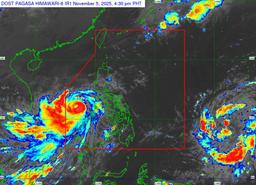
Typhoon Tino (international name Kalmaegi) further intensified over the West Philippine Sea on Wednesday afternoon, said the state weather bureau. However, it also forecasted that Tino will exit the Philippine Area of Responsibility (PAR) tomorrow morning.
In the Philippine Atmospheric, Geophysical and Astronomical Services Administration (PAGASA) 5:00 p.m. bulletin for November 5, the agency estimated that the eye of Typhoon Tino is 330 kilometers east of Northeast Pag-asa Island, Kalayaan in Palawan.
The typhoon packs maximum sustained winds of 140 km/hr near the center, with a gustiness of up to 170 km/hr. It is presently moving west northwestward at 30 km/hr.
At 11:00 a.m., Tino’s maximum sustained winds were only at 130 km/hr near the center, with a gustiness of up to 180 km/hr. It was moving at a speed of 20 km/hr.
Tropical Cyclone Wind Signal (TCWS) No. 2, indicating gale-force winds at speeds of 62 to 88 km/hr and a minor to moderate potential impact, is in effect in the Kalayaan Islands.
Meanwhile, TCWS No. 1 has been raised for Occidental Mindoro, including Lubang Islands, and the rest of Palawan, including Calamian and Cuyo Islands, which will experience strong winds at speeds of 39 to 61 km/hr and a minimal to minor potential impact.
“On the forecast track, TINO will continue moving west northwestward over the West Philippine Sea and exit the Philippine Area of Responsibility tonight or tomorrow (06 November) early morning,” PAGASA said.
Within the next 12 hours, Tino is said to re-intensify and may reach its peak intensity while over the West Philippine Sea.