
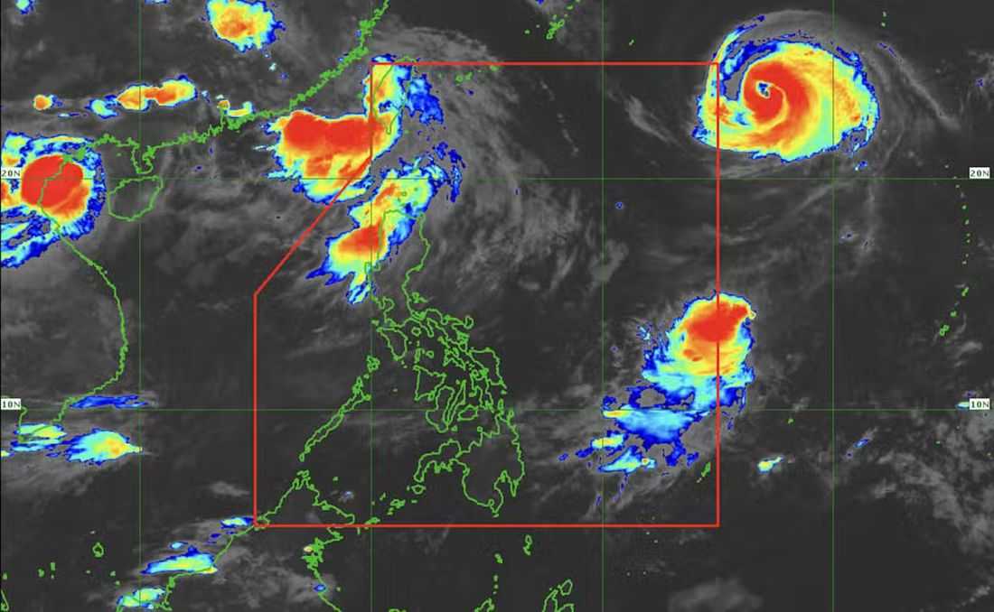
Typhoon Saudel is expected to enter the Philippine Area of Responsibility (PAR) on Monday morning or afternoon, August 24, while the southwest monsoon, or habagat, continues to affect parts of Northern and Central Luzon, according to the state weather bureau.
In its 5 a.m. weather forecast, the Philippine Atmospheric, Geophysical and Astronomical Services Administration (PAGASA) said Saudel was more than 1,600 kilometers east-northeast of the extreme northern portion of the PAR and was packing maximum sustained winds of 175 kilometers per hour near the center as of 3 a.m. Monday.
It is also expected to intensify into a 'super typhoon' before entering the PAR, according to PAGASA.
“Base sa ating forecast track, inaasahan na ito'y maging super typhoon kapag ito'y nasa loob ng ating Philippine Area of Responsibility,” weather specialist Aldczar Aurelio said.
If Saudel enters PAR, it will be given the local name “Obet.”
However, Aurelio said the cyclone is expected to move outside the PAR by Tuesday, August 25.
Meanwhile, PAGASA is also monitoring another tropical depression located more than 1,300 kilometers east of southeastern Luzon. The system has maximum sustained winds of 55 kilometers per hour near the center.
PAGASA said the tropical depression has a low chance of entering the PAR as it continues to move northeastward, away from the country.
The weather bureau is also monitoring Tropical Depression Gaenari, formerly Tropical Storm Neneng, which was located around 520 kilometers northwest of Itbayat, Batanes. Gaenari is expected to move westward toward China.
Saudel and Gaenari are enhancing the southwest monsoon, or habagat, which is currently affecting Northern and Central Luzon.
PAGASA said the effects of the southwest monsoon over Luzon are expected to persist for the next four days.
Rainy weather will continue over Batanes, while cloudy skies with scattered rain showers and thunderstorms are expected over Cagayan Valley, the Cordillera Administrative Region, Ilocos Region, Central Luzon, Metro Manila, Batangas, Cavite, and Rizal.
The rest of Luzon may experience partly cloudy to cloudy skies with chances of isolated rain showers or thunderstorms.
PAGASA warned residents of Batanes to remain vigilant as heavy rains may trigger flooding and landslides.
Meanwhile, the rest of the country is expected to experience partly cloudy to cloudy skies, with chances of isolated rain showers and thunderstorms.
As of Monday morning, PAGASA has not issued a gale warning, indicating that no dangerous sea conditions are currently expected. However, the public, particularly those in Luzon, is advised to remain cautious amid the ongoing rains.
