
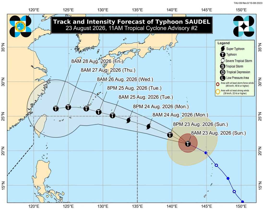
Typhoon Saudel is expected to enter the Philippine Area of Responsibility (PAR) by Monday, August 24, and could reach Super Typhoon category before entering the country’s monitoring zone, state weather bureau PAGASA said Sunday.
In its Tropical Cyclone Advisory No. 2 issued at 11 a.m. Sunday, PAGASA said Saudel was located 2,085 kilometers east of Extreme Northern Luzon, outside PAR, as of 10 a.m.
Saudel was packing maximum sustained winds of 165 kilometers per hour (kph) near the center, with gustiness of up to 205 kph and a central pressure of 945 hPa.
The typhoon was moving west-northwestward at 25 kph, with strong to typhoon-force winds extending up to 520 kilometers from its center.
PAGASA said Saudel is expected to continue moving generally west-northwestward over the next three days before shifting generally westward.
Based on the current forecast track, the typhoon may enter the northeastern boundary of PAR by Monday morning or afternoon.
The weather bureau said Saudel is forecast to intensify further and reach Super Typhoon category by Monday prior to its entry into PAR. While gradual weakening is expected after it reaches peak intensity, PAGASA said the possibility of Saudel entering PAR as a Super Typhoon cannot be ruled out.
Despite its projected intensity, PAGASA said Saudel is less likely to directly affect the country's weather and sea conditions within the next three days, as it is expected to remain over the Philippine Sea.
The agency also noted that the possibility of another Tropical Depression located east of Southern Luzon, outside PAR, entering the country's monitoring zone has not been ruled out.
Saudel will be assigned the next appropriate Philippine local name—Obet or Pilandok—depending on which system enters PAR first.
Under the current forecast, Saudel is expected to exit PAR by Tuesday, August 25. However, PAGASA warned that a more westward track beyond 48 hours could result in the typhoon remaining inside PAR beyond Tuesday.
PAGASA urged the public and disaster risk reduction and management offices to continue monitoring official updates as Saudel approaches the PAR boundary.
The next tropical cyclone advisory is scheduled for 11 p.m. Sunday, unless an intermediate advisory is issued.
