
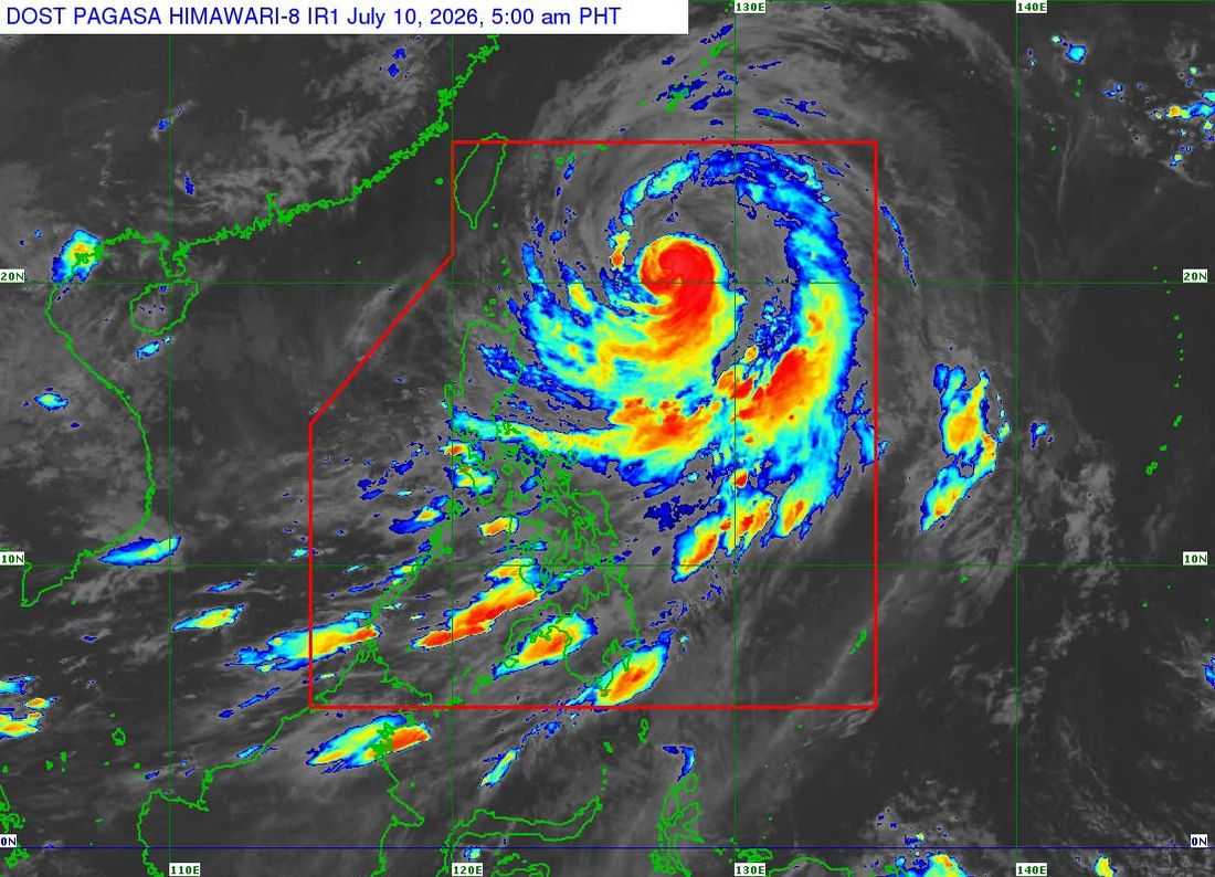
Typhoon Inday (international name: BAVI) has weakened slightly but continues to accelerate northwestward over the Philippine Sea east of Batanes, while maintaining a broad circulation that is expected to enhance the Southwest Monsoon (habagat) and bring strong winds over much of the country, the Philippine Atmospheric, Geophysical and Astronomical Services Administration (PAGASA) said Friday.
In its 5:00 a.m. tropical cyclone bulletin, PAGASA said the center of Typhoon Inday was estimated at 620 kilometers east of Basco, Batanes as of 4:00 a.m.
The typhoon packs maximum sustained winds of 150 kilometers per hour, gustiness of up to 185 km/h, and is moving northwestward at 20 km/h.
Despite weakening further, Inday remains a powerful typhoon, with strong to typhoon-force winds extending up to 860 kilometers from its center.
Wind Signals remain in Northern Luzon
PAGASA maintained Tropical Cyclone Wind Signal (TCWS) No. 2 over:
- Batanes
- Eastern portion of the Babuyan Islands (Babuyan, Didicas, and Camiguin Islands)
- Northeastern portion of mainland Cagayan, including Santa Ana
These areas may experience gale-force winds of 62 to 88 km/h within 24 hours, posing a minor to moderate threat to life and property.
Meanwhile, TCWS No. 1 remains hoisted over:
- The rest of Babuyan Islands
- The rest of mainland Cagayan
- Isabela
- Apayao
- Ilocos Norte
- Kalinga
- Portions of Abra, Mountain Province, and Ifugao
Residents in these areas may experience strong winds of 39 to 61 km/h within 36 hours.
Habagat to affect most of the country
Aside from the direct effects of the typhoon, PAGASA warned that Inday's circulation will continue to enhance the Southwest Monsoon, bringing strong to gale-force gusts across most parts of the Philippines today and Saturday.
The weather bureau also advised the public to monitor heavy rainfall advisories as localized flooding and rain-induced landslides remain possible in vulnerable areas.
Dangerous sea conditions
A Gale Warning remains in effect over the northern and eastern seaboards of Luzon, where waves may reach up to seven meters, particularly along the northern and eastern coasts of Batanes.
Sea travel remains extremely risky, prompting PAGASA to advise all vessels to remain in port or seek safe harbor until conditions improve.
Small fishing boats and motor bancas are likewise advised not to venture into rough to very rough waters affecting several coastal areas in Luzon, Visayas, and parts of Mindanao.
Forecast track
PAGASA said Inday is expected to continue moving northwestward while remaining over the Philippine Sea and may make its closest approach to Extreme Northern Luzon between Friday night and Saturday morning.
The typhoon is then forecast to move toward the southern islands of Japan, pass close to or make landfall over northern Taiwan, and exit the Philippine Area of Responsibility (PAR) by Saturday morning or afternoon.
After leaving the PAR, Inday is expected to make landfall over the eastern coast of mainland China by Saturday evening or early Sunday, where it is forecast to weaken into a severe tropical storm.
PAGASA urged residents, particularly those in areas prone to flooding, landslides, storm surges, and strong winds, to continue monitoring official weather bulletins and follow evacuation orders and advisories from local authorities.
