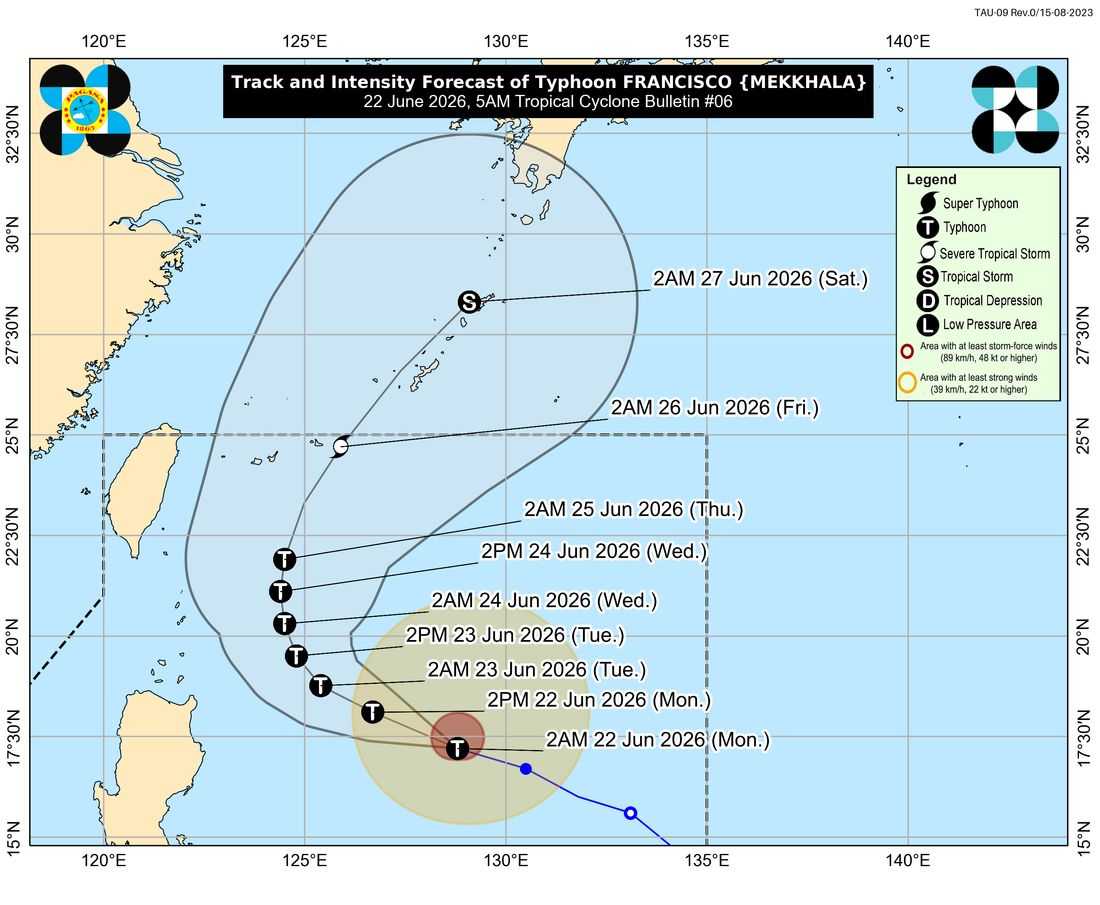
Typhoon “Francisco” intensified further and accelerated over the Philippine Sea early Monday, June 22, with the PAGASA warning that the cyclone could reach its peak intensity by Tuesday.
In its 5 a.m. tropical cyclone bulletin, PAGASA said the center of Typhoon Francisco was estimated at 715 kilometers east of Tuguegarao City, Cagayan, moving west northwestward at 30 kilometers per hour.
The typhoon packs maximum sustained winds of 140 kilometers per hour near the center and gusts of up to 170 kilometers per hour.
Tropical Cyclone Wind Signal No. 1 remains hoisted over Batanes and the northeastern portion of Cagayan, including the municipalities of Gonzaga and Santa Ana, as well as the eastern part of the Babuyan Islands.
According to PAGASA, minimal to minor impacts from strong winds are possible in areas under the wind signal.
Meanwhile, the southwest monsoon or habagat, enhanced by Francisco, is expected to bring strong to gale-force gusts over several parts of the country. These include La Union, Pangasinan, CALABARZON, Romblon, Masbate, most of the Visayas, Zamboanga Peninsula, parts of Northern Mindanao, Surigao del Norte, Dinagat Islands, Davao Occidental, and Davao Oriental.
The weather bureau also warned mariners against venturing out to sea, particularly along the eastern seaboards of Babuyan Islands and mainland Cagayan where rough seas of up to 3.5 meters are expected. Rough seas reaching up to 3 meters are also forecast along the eastern coasts of Batanes and Isabela.
Motorbancas and other small vessels were advised to exercise caution or avoid navigation due to hazardous sea conditions.
PAGASA emphasized that heavy rainfall and strong winds may still occur outside the forecast confidence cone and noted that a closer approach to Extreme Northern Luzon remains possible should the typhoon shift farther west.
Francisco is expected to continue moving west northwestward until Tuesday before slowing down and eventually recurving. The cyclone is forecast to remain over the Philippine Sea throughout the outlook period and may exit the Philippine Area of Responsibility by Friday, June 26.
While further intensification is expected through Tuesday, PAGASA said a weakening trend may begin afterward.