
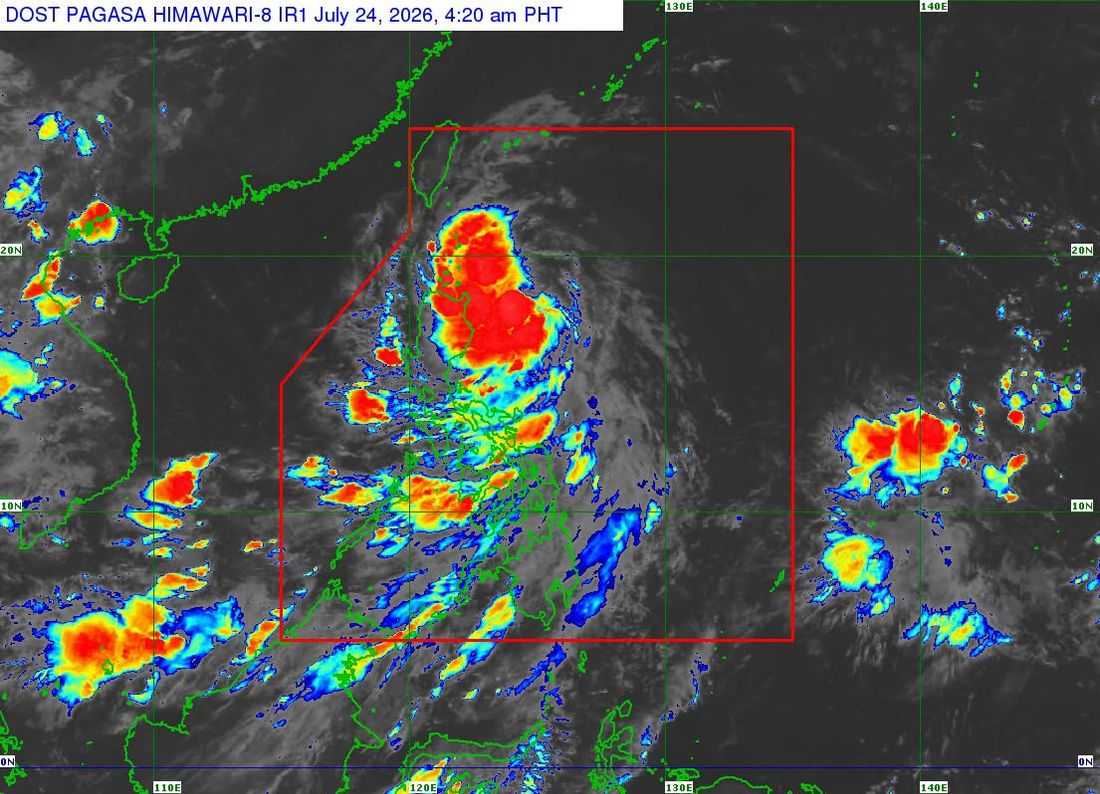
Tropical Storm Kiyapo (international name: Noul) intensified early Friday as it moved closer to Extreme Northern Luzon, prompting PAGASA to raise Tropical Cyclone Wind Signal (TCWS) No. 2 over parts of Northern Luzon.
In its 5 a.m. bulletin, PAGASA said the center of Kiyapo was estimated 345 kilometers east of Aparri, Cagayan, with maximum sustained winds of 65 kilometers per hour, gusts of up to 80 km/h, and moving west northwestward at 30 km/h.
The following wind signals are in effect:
TCWS No. 2 (Gale-force winds of 62–88 km/h; minor to moderate threat to life and property)
- Batanes
- Babuyan Islands
- Northern mainland Cagayan: Santa Ana, Gonzaga, Santa Teresita, Buguey, Camalaniugan, Aparri, Ballesteros, Abulug, Pamplona, Sanchez-Mira, Claveria, and Santa Praxedes
- Northern Ilocos Norte: Pagudpud
TCWS No. 1 (Strong winds of 39–61 km/h; minimal to minor threat to life and property)
- Rest of mainland Cagayan
- Isabela
- Nueva Vizcaya
- Quirino
- Apayao
- Abra
- Kalinga
- Mountain Province
- Ifugao
- Benguet
- Rest of Ilocos Norte
- Ilocos Sur
- La Union
- Northern and central Aurora: Dilasag, Casiguran, Dinalungan, and Dipaculao
PAGASA warned that TCWS No. 3 may still be raised should Kiyapo intensify into a severe tropical storm while traversing the Batanes-Babuyan Islands area.
The weather bureau also said the Southwest Monsoon (Habagat) enhanced by Kiyapo will bring strong to gale-force wind gusts across most parts of the country on Friday, with similar conditions expected over most of Luzon and the Visayas on Saturday.
A Gale Warning remains in effect over the northern seaboard of Northern Luzon, where very rough seas of up to 5.5 meters are forecast over the waters off Batanes and the Babuyan Islands, and up to 4.5 meters along the northern coast of mainland Cagayan and Ilocos Norte.
PAGASA advised all vessels to remain in port or seek safe harbor, warning that sea travel is dangerous for all types of watercraft in affected areas.
Based on the latest forecast, Kiyapo is expected to continue moving west northwestward toward the Luzon Strait before turning northwestward to northward. The storm may pass close to northeastern Cagayan between Friday morning and afternoon before passing very close to or making landfall over the Babuyan Islands later in the day.
The tropical storm is forecast to exit the Philippine Area of Responsibility (PAR) by Saturday morning. However, PAGASA said Kiyapo may strengthen into a severe tropical storm after passing the Babuyan Islands and could rapidly intensify into a typhoon over the West Philippine Sea before making landfall in southern mainland China.
Authorities urged residents in areas vulnerable to flooding, landslides, strong winds, and rough seas to remain alert, follow evacuation orders if necessary, and continue monitoring official weather advisories from PAGASA.
