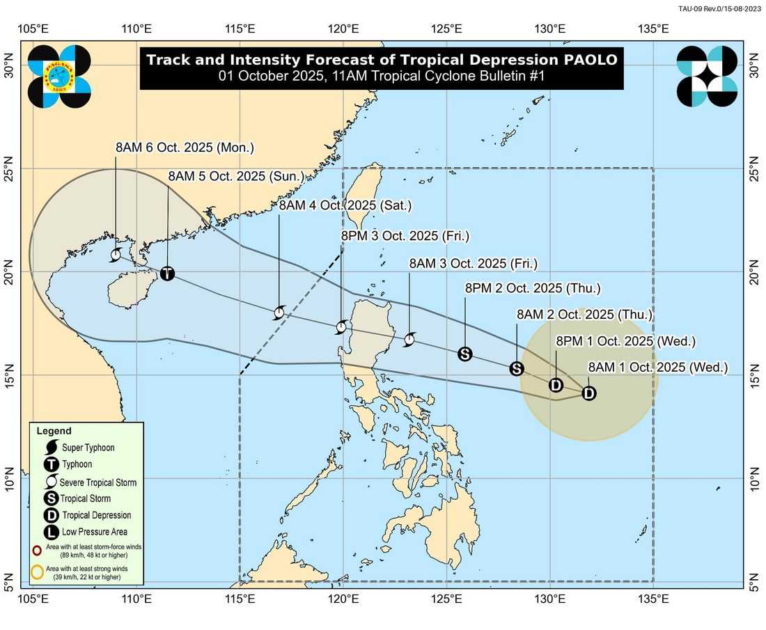
The low-pressure area east of Southern Luzon has developed into Tropical Depression Paolo (#PaoloPH), according to the Philippine Atmospheric, Geophysical and Astronomical Services Administration (PAGASA).
As of 7:00 AM Wednesday, Paolo was located 760 kilometers east of Virac, Catanduanes, with maximum sustained winds of 45 km/h near the center, gustiness of up to 55 km/h, and central pressure of 1004 hPa. The system is moving westward at 25 km/h.
No Tropical Cyclone Wind Signals (TCWS) have been raised so far. However, PAGASA warned that Signal No. 1 may be issued over the eastern sections of Northern and Central Luzon as early as Wednesday afternoon or evening.
Depending on its development, the highest possible signal that could be raised is Signal No. 3, although Signal No. 4 is not ruled out if "Paolo" reaches typhoon category before landfall.
Rainfall and Wind Outlook
"Paolo" is not expected to directly affect the country’s weather within the next 24 hours. However, heavy rains may begin by Friday, October 3, particularly in Northern Luzon and parts of Central Luzon. PAGASA may issue a weather advisory today in anticipation of the rains.
Moderate to rough seas are expected over the coastal waters of Northern and Central Luzon starting Friday morning.
A Gale Warning may be raised by Thursday afternoon. PAGASA also warned of the risk of storm surges and coastal flooding in low-lying areas once the storm approaches.
Forecast Track
The tropical depression is forecast to move west-northwestward, possibly making landfall over Isabela or northern Aurora on Friday morning or afternoon. Forecasters noted that Paolo is expected to strengthen into a severe tropical storm by Friday morning, with the possibility of intensifying further into a typhoon before landfall.
Authorities urged the public and local disaster risk reduction offices to take precautionary measures, particularly in flood-prone and landslide-prone areas. Residents in coastal communities of Northern and Central Luzon are also advised to prepare for potential storm surges.
The next tropical cyclone bulletin will be released at 5:00 PM today.