
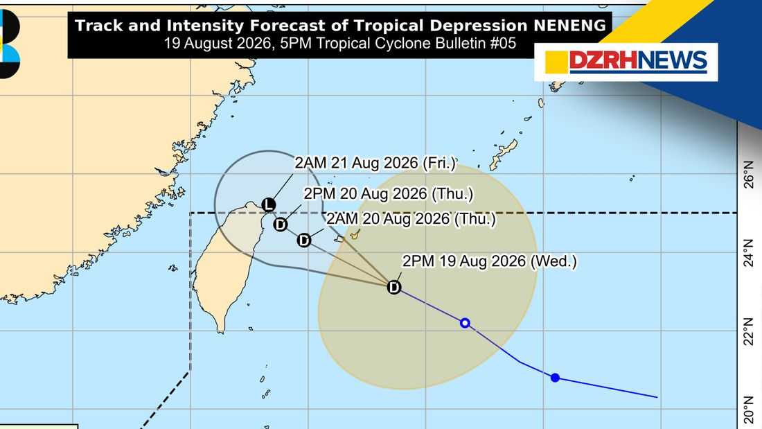
Tropical Depression “Neneng” slightly weakened while moving west-northwestward over the sea east of Central Taiwan as of 5 p.m. Wednesday, August 19, according to the Philippine Atmospheric, Geophysical and Astronomical Services Administration (PAGASA).
In its 5 p.m. tropical cyclone bulletin, PAGASA said Neneng is expected to remain a tropical depression over the next 24 hours as it moves toward Taiwan.
The weather agency said Neneng may pass close to or make landfall over the northern coast of Taiwan by Thursday evening, August 20, or early Friday morning, August 21. The center of the tropical depression is expected to remain over the Philippine Sea throughout the forecast period.
PAGASA said Neneng is likely to weaken into a remnant low over or near Taiwan by Friday morning, although earlier weakening cannot be ruled out.
Strong Winds Expected
Despite Neneng’s weakening, PAGASA warned that the Southwest Monsoon (habagat) will continue to bring strong to gale-force wind gusts over several parts of the country.
From Wednesday through Thursday, August 20, strong to gale-force gusts are expected over most of Luzon and Visayas, the Zamboanga Peninsula, Northern Mindanao, and the Davao Region, particularly in coastal and upland areas exposed to the winds.
On Friday, August 21, similar conditions are expected over most of Luzon, Panay Island, Negros Occidental, Northern Samar, and Davao Oriental.
PAGASA also reminded the public that heavy rainfall and strong winds may still occur outside Neneng’s forecast track and confidence cone.
Rough Seas Expected
PAGASA warned of rough to moderate seas across several coastal waters.
Wave heights of up to 3.5 meters are forecast along the seaboards of Ilocos Norte and Batanes.
Seas of up to 3.0 meters are expected along the seaboards of Ilocos Sur, La Union, Zambales, and the Lubang Islands, as well as the western seaboards of Babuyan Islands, Pangasinan, Bataan, Batangas, Occidental Mindoro, and Calamian Islands, and the northern seaboard of the Kalayaan Islands.
Meanwhile, wave heights of up to 2.5 meters are expected along the seaboard of Isabela, the western seaboards of Cavite and northern mainland Palawan, the eastern seaboard of Davao Oriental, and the remaining seaboards of Occidental Mindoro and the Kalayaan Islands.
PAGASA also forecast seas of up to 2.0 meters in several other coastal areas, including parts of Cagayan, Aurora, Romblon, Palawan, Antique, Catanduanes, Iloilo, Surigao del Sur, Dinagat Islands, and Siargao-Bucas Grande Islands.
The agency advised operators of motorbancas and similarly sized vessels to take necessary precautions and, if possible, avoid sailing under these conditions.
PAGASA said the next tropical cyclone bulletin on Neneng will be issued at 11 p.m. Wednesday, August 19.
