
Tropical Depression Neneng accelerated as it moved over the coastal waters of eastern Taiwan, while the state weather bureau continued to monitor two other tropical disturbances outside the Philippine Area of Responsibility (PAR).
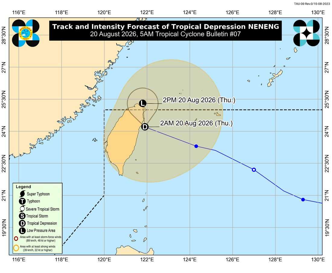
In its 5 a.m. bulletin on Thursday, August 20, the Philippine Atmospheric, Geophysical and Astronomical Services Administration (PAGASA) said Neneng was last located 390 kilometers north of Itbayat, Batanes.
Neneng was packing maximum sustained winds of 45 kilometers per hour near the center and gustiness of up to 55 kph. It was moving west-northwestward at a faster pace of 30 kph, with strong winds extending as far as 420 kilometers from the center.
PAGASA said Neneng may continue moving over the waters off Taiwan's eastern coast or make landfall over the northern portion of the island. The storm is expected to slow down as it moves northward and could weaken into a remnant low within the next 12 hours.
No tropical cyclone wind signal is currently raised over any part of the country.
Despite Neneng's distance from the Philippines, PAGASA said the southwest monsoon or Habagat would continue to bring rains and strong to gale-force winds over parts of the country.
For Thursday, habagat may still affect large parts of Luzon and the Visayas, as well as the Zamboanga Peninsula, Northern Mindanao and the Davao Region.
On Friday, August 21, areas that may experience the effects of the enhanced Habagat include large parts of Luzon, Panay Island, Negros Occidental, Northern Samar and Davao Oriental.
By Saturday, August 22, most parts of Luzon and the Visayas, as well as Davao Oriental, may again experience the effects of the southwest monsoon.
PAGASA said the Habagat is expected to weaken along with Neneng, resulting in generally improving weather conditions across most parts of Luzon over the next few days.
However, cloudy skies and occasional rains may persist, particularly over the Ilocos Region, Zambales, Bataan and Occidental Mindoro from Friday to Saturday.
Meanwhile, PAGASA is also monitoring two other tropical disturbances outside the PAR.
A tropical depression located about 1,100 kilometers west of Extreme Northern Luzon is moving slowly southwestward at 10 kph. It has maximum sustained winds of 45 kph near the center and gustiness of up to 55 kph. PAGASA said it may eventually make landfall in Vietnam or southern mainland China.
Another tropical cyclone, with an international name, Tropical Storm Saudel, was last located about 2,960 kilometers east of northeastern Mindanao as of 3 a.m. Thursday.
Saudel remains outside the PAR and is not currently affecting the country. PAGASA said it could intensify into a typhoon over the weekend as it moves west-northwestward across the Pacific Ocean.
The weather bureau said Saudel may enter the PAR between Sunday and Monday through its northeastern boundary. Once inside the Philippine monitoring zone, the storm would be given the local name Obet.
PAGASA warned that Saudel could enhance the southwest monsoon beginning Sunday, potentially bringing another increase in rainfall and flooding from Sunday into Monday and the following days.
