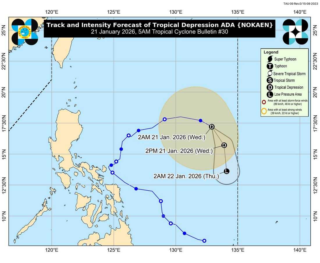
Tropical Depression Ada continues to move east-southeastward while over the sea east of Northern Luzon on Wednesday, January 21, according to the latest weather bulletin.
As of 4:00 a.m., the center of Tropical Depression Ada was estimated at 1,215 kilometers east of Northern Luzon (17.0°N, 133.1°E). It has a maximum sustained winds of 55 kilometers per hour near the center, with gusts of up to 70 kilometers per hour, and a central pressure of 1000 hPa.
Ada is moving east-southeastward at 20 kilometers per hour, with strong winds extending up to 440 kilometers from the center.
No Tropical Cyclone Wind Signal is currently in effect in any part of the country.
However, the surge of the Northeast Monsoon is expected to bring strong to gale-force winds over large portions of the country, particularly in coastal and upland areas. For Wednesday (January 21), strong winds may affect most of Luzon, the Visayas, Caraga, the Davao Region, the Zamboanga Peninsula, Camiguin, Misamis Oriental, Lanao del Norte, Basilan, and Tawi-Tawi. Similar conditions are forecast to persist on Thursday (January 22) and Friday (January 23) across most of Luzon, the Visayas, and parts of Mindanao.
A Gale Warning remains in effect over the eastern seaboards of Luzon and the northern and western seaboards of Northern Luzon. Sea conditions are expected to be dangerous, with very rough seas reaching up to 5.5 meters along the seaboards of Batanes, the Babuyan Islands, Isabela, and mainland Cagayan. Rough to moderate seas are also forecast in several other coastal areas across Luzon, Visayas, and Mindanao.
Authorities warned that sea travel is risky for all types of vessels in affected areas. Mariners are advised to remain in port or seek shelter until conditions improve, while operators of small seacraft are urged not to venture out to sea.
PAGASA said Tropical Depression Ada is expected to continue moving generally southeastward over the next 24 hours.
Due to the continued entrainment of dry air from the northeast monsoon, the system may weaken further and could be downgraded into a low pressure area later today (January 21) or early tomorrow (January 22).
Meanwhile, another low-pressure area is being monitored outside the Philippine Area of Responsibility (PAR) but has a low chance of developing into a tropical depression, according to PAGASA.