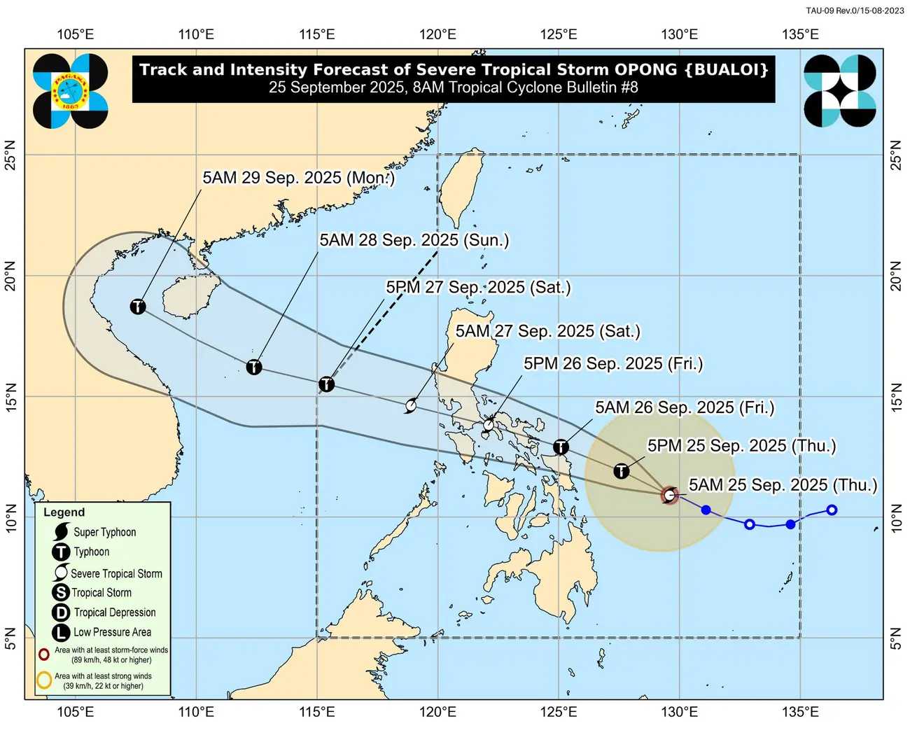
As of 7:00 a.m., Severe Tropical Storm Opong was about 365 kilometers east of Guiuan in Eastern Samar, moving northwest at 20 kilometers per hour.
The Philippine Atmospheric, Geophysical and Astronomical Services Administration (PAGASA) noted that winds may be stronger in coastal and mountainous areas. The highest wind signal that could be issued during Opong’s passage is Wind Signal No. 4.
Wind Warnings (Tropical Cyclone Wind Signals):
-
TCWS No. 2: Affects eastern and southern Camarines Sur, Catanduanes, Albay, Sorsogon, eastern Masbate, Northern Samar, northern and central Eastern Samar, northern and central Samar, and northern Biliran. Residents may face minor to moderate threats to life and property.
-
TCWS No. 1: Covers the rest of Masbate, Camarines Sur, Camarines Norte, Marinduque, Romblon, Mindoro provinces, parts of Luzon including Metro Manila, Bulacan, Zambales, Pangasinan, and some areas in Visayas and Mindanao. Minimal to minor impacts are expected.
Heavy Rain and Southwest Monsoon Effects:
Opong, along with the Southwest Monsoon, is expected to bring heavy rain and strong winds across northern and central Luzon, parts of Visayas, and Mindanao through the weekend. Low-lying and mountainous areas may experience localized flooding and landslides.
Coastal Hazards:
-
Very rough to high seas (up to 11 meters): Eastern coasts of Catanduanes, Albay, Sorsogon, and Northern Samar.
-
Rough to moderate seas (2.5–5 meters): Northeastern Eastern Samar, northern coasts of Camarines Norte and Sur, Polillo Islands, and some northern coastal areas of Mindanao and Visayas.
Mariners are strongly advised to stay in port or seek safe shelter. Small boats and motorbancas should avoid going out to sea.
Storm Surge Risk:
Low-lying coastal areas in Aurora, Zambales, Bataan, Metro Manila, CALABARZON, Occidental and Oriental Mindoro, Marinduque, Romblon, Bicol Region, and parts of Visayas may experience life-threatening storm surges up to 1–3 meters.
Forecast Track and Intensity:
Opong is expected to reach Eastern Visayas and the Bicol Region by Friday morning or early afternoon. It may make landfall in Bicol, cross Southern Luzon, and move over the West Philippine Sea by Saturday. The storm could strengthen to typhoon level before landfall, weaken while crossing the archipelago, and potentially intensify again over open waters.
Authorities and residents in high-risk areas are urged to take precautions and follow local disaster management instructions. PAGASA will release the next tropical cyclone bulletin at 11:00 a.m.