
Parts of the Visayas and Mindanao remain under Tropical Cyclone Wind Signal No. 2 as Tropical Storm Basyang continues to maintain its strength while traversing Agusan del Norte, PAGASA on Friday, February 6.
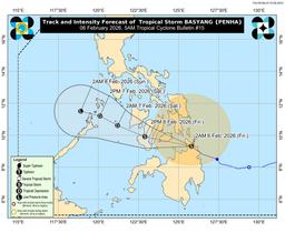
As of 5:00 a.m., the center of Basyang was estimated near Jabonga, Agusan del Norte, moving west-northwestward at 25 kilometers per hour. The storm has maximum sustained winds of 65 kilometers per hour near the center and gusts of up to 90 kilometers per hour.
PAGASA said Basyang is expected to continue moving generally west-northwestward and will emerge over the Bohol Sea later this morning. The storm may pass close to or make another landfall over Bohol and the southern portions of Cebu and Negros Oriental before crossing the Sulu Sea, passing near the Cuyo Islands, and traversing northern Palawan.
Basyang is forecast to remain a tropical storm while moving across the Central and Western Visayas, but may weaken into a tropical depression by tonight or Saturday morning. It is expected to further downgrade into a low pressure area by Sunday.
Under Wind Signal No. 2 in the Visayas are the southern portion of Leyte, Southern Leyte, Bohol, central and southern portions of Cebu, Siquijor, Negros Oriental, and the southern portion of Negros Occidental. In Mindanao, Signal No. 2 remains in effect over Dinagat Islands, Surigao del Norte, northern Surigao del Sur, Agusan del Norte, northern Agusan del Sur, Camiguin, Misamis Oriental, northern Bukidnon, and eastern Misamis Occidental.
PAGASA warned of minor to moderate impacts from gale-force winds in these areas, particularly in coastal and upland communities.
Wind Signal No. 1 is raised over parts of Luzon, Visayas, and Mindanao, including portions of Mindoro, Romblon, northern Palawan, Masbate, Eastern Samar, Samar, Biliran, the rest of Leyte, Cebu, Negros Occidental, Western Visayas, and several provinces in Mindanao.
Heavy rainfall is also expected in areas along the storm’s track, with possible flooding and landslides in low-lying and mountainous areas. PAGASA said there is a minimal to moderate risk of storm surge of up to two meters in several coastal areas in Mindoro, Palawan, Visayas, and parts of Mindanao.
A gale warning remains in effect over the eastern and central seaboards of the Visayas and the northern and eastern seaboards of Mindanao, where very rough seas of up to five meters are possible. Sea travel is considered risky, and mariners are advised to remain in port or seek safe harbor until conditions improve.
PAGASA emphasized that heavy rains and strong winds may still affect areas outside the forecast track and urged the public and local government units to continue monitoring official weather advisories and take necessary precautions.