
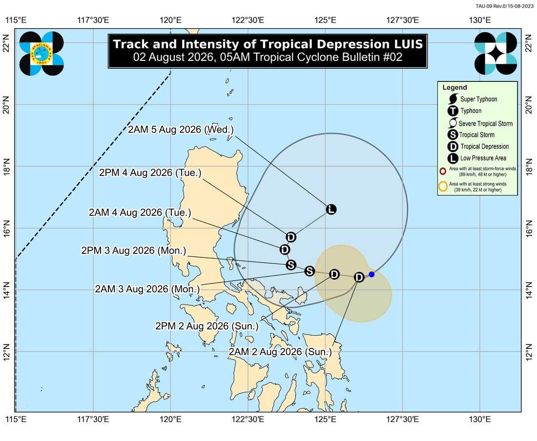
The Philippine Atmospheric, Geophysical and Astronomical Services Administration (PAGASA) has raised Tropical Cyclone Wind Signal (TCWS) No. 1 over several areas in Luzon as Tropical Depression Luis slightly intensified while moving slowly east of the Bicol Region.
In its 5 a.m. bulletin on Sunday, PAGASA said the center of the tropical depression was estimated at 295 kilometers east of Daet, Camarines Norte.
The cyclone was moving west-southwestward at a slow pace, packing maximum sustained winds of 55 kilometers per hour near the center and gusts of up to 70 kilometers per hour.
TCWS No. 1 remains in effect over the following areas:
- Polillo Islands
- Camarines Norte
- Catanduanes
- The northern portion of Camarines Sur, including the municipalities of Caramoan, Presentacion, Garchitorena, Lagonoy, Tinambac, Siruma, Goa, San Jose, Tigaon, and Calabanga
PAGASA said residents in these areas could experience minimal to minor impacts from strong winds. The agency also noted that the possibility of raising TCWS No. 2 has not been ruled out.
Aside from strong winds, Luis and the southwest monsoon are expected to bring heavy rainfall and gusty conditions to several parts of the country.
On Saturday, strong to gale-force gusts are expected in Marinduque, the southern portions of Oriental Mindoro and Occidental Mindoro, Romblon, mainland Masbate, the Caluya Islands, Siquijor, Southern Leyte, Camiguin, and Dinagat Islands.
From Sunday until Tuesday, most parts of Luzon and the Visayas are expected to experience strong winds, along with several areas in Mindanao.
PAGASA also warned mariners of rough sea conditions, particularly along the eastern coast of Davao Oriental, where waves may reach up to 2.5 meters in height.
According to the state weather bureau, Luis is expected to intensify into a tropical storm within the next 24 hours while remaining over the Philippine Sea. However, it is expected to weaken as it begins to move northeastward and may eventually be absorbed by the circulation of Super Typhoon Dolphin.
Although the cyclone is forecast to remain over open waters, PAGASA warned that a westward shift in its track could bring it closer to Northern or Central Luzon.
