The Philippine Atmospheric Geophysical and Astronomical Services Administration (PAGASA) on Tuesday, May 12, 2026, reported that two low pressure areas (LPAs) are currently being monitored, although neither is expected to directly affect the country or develop into tropical cyclones.
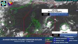
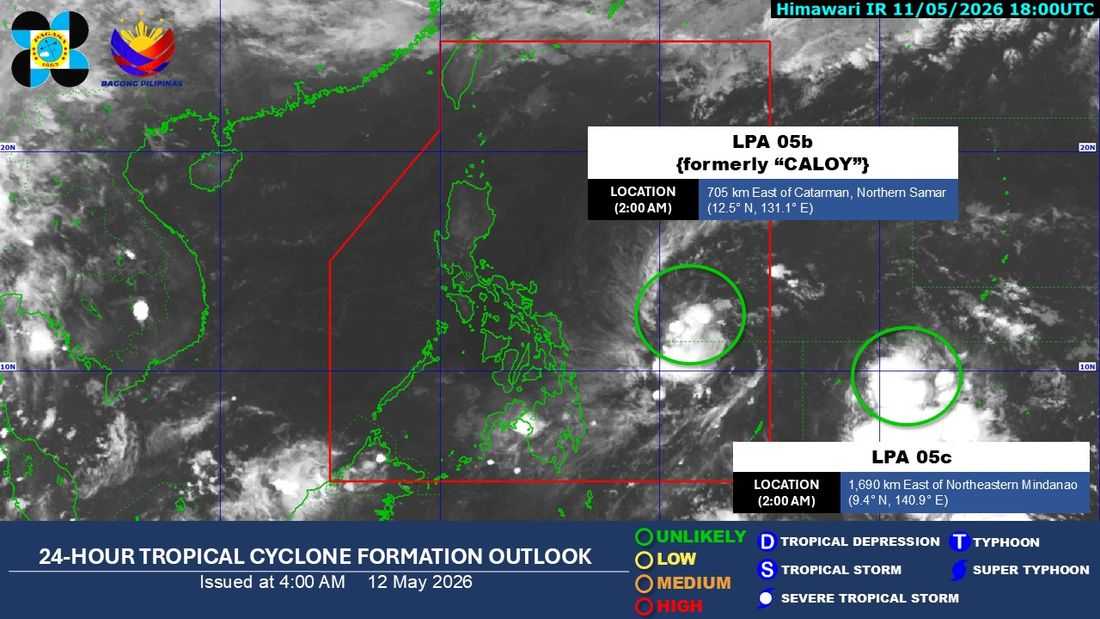
Based on the latest satellite data, PAGASA said the first LPA—formerly Tropical Depression “Caloy”—has already weakened into a low-pressure area. As of 3:00 a.m., it was last located about 690 kilometers east of Catarman, Northern Samar.
Weather specialists said this system is no longer expected to redevelop into a tropical cyclone and will not bring direct impacts to any part of the Philippines.
Meanwhile, another LPA outside the Philippine Area of Responsibility (PAR) was last spotted around 1,680 kilometers east of Northeastern Mindanao. PAGASA noted that it has a very low chance of developing into a tropical cyclone and is also not expected to enter PAR or affect the country.
Fair weather with afternoon thunderstorms
For Luzon, including Metro Manila, PAGASA forecast partly cloudy to cloudy skies with isolated thunderstorms in the afternoon. The agency said hot and humid conditions will continue throughout the day.
Fair weather conditions are expected to persist in the next three to five days, although localized thunderstorms may still occur in the afternoon. PAGASA also noted a possible increase in rainfall over the eastern section of Northern Luzon by Saturday.
Temperature forecast
The following temperature ranges were forecast for key areas:
- Metro Manila: 27°C to 35°C
- Baguio: 18°C to 26°C
- Laoag: 26°C to 33°C
- Tuguegarao: 27°C to 39°C
- Legazpi: 25°C to 33°C
- Tagaytay: 23°C to 33°C
- Puerto Princesa: 27°C to 33°C
For the Visayas and Mindanao, generally fair and hot weather will prevail in the morning to midday, with increased chances of localized thunderstorms in the afternoon.
- Iloilo and Tacloban: 26°C to 33°C
- Cebu and Zamboanga: up to 33°C
- Cagayan de Oro: 26°C to 32°C
- Davao: 26°C to 35°C
High heat index continues
PAGASA also reported high heat index levels in recent days, with Metro Manila recording 41°C to 42°C, while Kamiling, Tarlac reached up to 45°C.
For today, similar conditions are expected, with heat index levels again reaching:
- Metro Manila: 41°C to 42°C
- Tuguegarao City: up to 45°C
- Echague, Isabela: 44°C
- Casiguran, Aurora: 44°C
- Kamiling, Tarlac: 44°C
- San Jose, Occidental Mindoro: 44°C
- Cuyo, Palawan: 44°C
- Borongan, Eastern Samar: 44°C
PAGASA said no gale warnings are currently in effect across any seaboards of the country.
In Metro Manila, sunrise is at 5:29 a.m., while sunset will be at 6:16 p.m.
PAGASA reminded the public to stay updated through its official platforms as hot and humid conditions continue nationwide.