
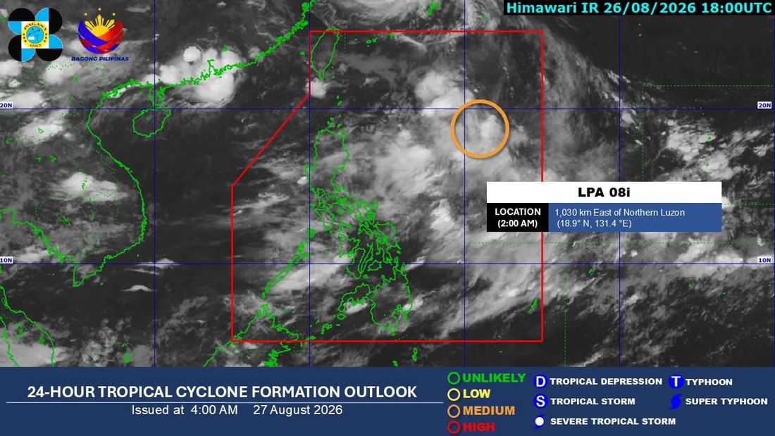
A low pressure area (LPA) was being monitored inside the Philippine Area of Responsibility (PAR) and may develop into a tropical depression within the next 48 hours, while the southwest monsoon, or Habagat, will bring occasional rains to parts of Luzon and the western Visayas, the state weather bureau said Thursday, Aug. 27.
In its 5 a.m. weather forecast, the Philippine Atmospheric, Geophysical and Astronomical Services Administration (PAGASA) said, as of 3 a.m., the LPA was located about 1,030 kilometers east of extreme Northern Luzon.
“Posibleng maging bagyo itong LPA within the next 48 hours at kung maging bagyo dahil nasa loob na ito ng PAR, tatawagin itong Pilandok,” weather specialist Leanne Loreto said.
PAGASA said the weather disturbance is currently not directly affecting the country and is expected to move west-northwestward toward Taiwan in the coming days.
Despite the low possibility of the system making landfall in any part of the country, PAGASA warned that its indirect effects could be significant as it is expected to enhance the southwest monsoon, or Habagat.
The enhanced Habagat is expected to bring heavier rains over Luzon and the western section of the Visayas from the weekend through Tuesday next week.
PAGASA said moderate to heavy rains may affect Zambales and Occidental Mindoro on Thursday, spreading to Benguet, La Union, Pangasinan and Bataan on Friday.
By Saturday, heavy to intense rains are expected over Zambales, Bataan and Occidental Mindoro, while Metro Manila and other areas in western Luzon may experience moderate to heavy rainfall.
More than 50 millimeters of rain could fall over some areas, with localized flooding and landslides possible.
PAGASA said rainfall could become more intense on Saturday and Sunday, with some areas, particularly Zambales, Bataan and Occidental Mindoro, potentially receiving as much as 200 millimeters of rain.
Other areas that could experience heavy rains include Abra, Ilocos Sur, La Union, Pangasinan, Benguet, Nueva Ecija, Tarlac, Pampanga, Bulacan, Rizal, Metro Manila, Cavite and Batangas.
The weather agency said the critical period for heavy rainfall could continue through Tuesday, urging residents in vulnerable areas to remain alert for possible flooding and landslides.
Meanwhile, the Habagat is expected to continue affecting Palawan and the western Visayas, where cloudy skies and rain are likely.
The eastern part of Luzon may also experience cloudy weather and rain, while thunderstorms remain possible over northern Luzon from afternoon to evening.
PAGASA also noted that parts of the Visayas and Mindanao will continue to experience hot and humid conditions, with drought conditions still being monitored in some areas.
The weather agency said the southwest monsoon is also being enhanced by the remnants of Typhoon Obet, which is moving toward mainland China.
Despite the expected worsening of the Habagat, PAGASA said no gale warning is currently in effect, allowing fishermen and other sea vessels to sail, subject to prevailing weather conditions.
